


Satellite technology is helping South African authorities understand the scale of a major industrial disaster near Brits, demonstrating that space science isn’t only about studying distant planets and galaxies.
The South African National Space Agency (SANSA) revealed on 21 August 2026 that it is using satellite Earth Observation intelligence to map and analyse the aftermath of the Hernic Ferrochrome tailings dam collapse.
Satellite imagery is providing researchers and decision-makers with a detailed view of how tailings and sludge have travelled downstream from the mining area, including potential impacts on roads, electricity infrastructure and surrounding areas.
For South Africans interested in astronomy and space technology, the response provides an important reminder of something we sometimes overlook:
Some of the most valuable work performed by satellites happens while they’re looking back at Earth.
Sentinel-2 Reveals the Extent of the Damage
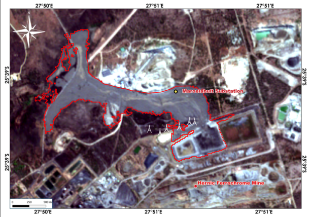
SANSA‘s analysis incorporates imagery from Sentinel-2, part of Europe’s Copernicus Earth Observation programme.
According to SANSA, Sentinel-2 imagery acquired following 13 August 2026 shows extensive visible sludge deposition surrounding the Hernic Ferrochrome mining area near Brits.
The satellite observations allow analysts to trace the downstream movement and deposition of material following the tailings dam collapse.
Importantly, the imagery isn’t merely showing an environmental disturbance.
It is helping reveal how the disaster intersects with infrastructure.
SANSA reports that impacts visible through the satellite analysis extend towards the Maroelabult Substation and Eskom power lines. The affected access route leading from the R566 can also be identified in the imagery.
That provides authorities with a much broader perspective than individual observations made at ground level.
Seeing a Disaster From Space
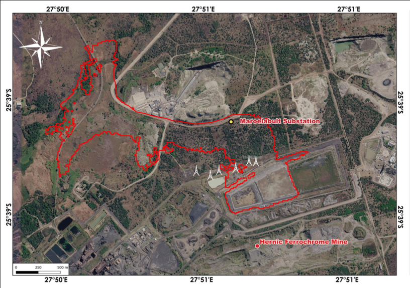
Earth Observation satellites can repeatedly photograph enormous areas of the planet.
That becomes particularly useful following disasters.
Emergency personnel on the ground may encounter blocked roads, dangerous terrain or areas that are simply too large to assess quickly. Satellite observations provide another layer of intelligence, allowing analysts to examine the geographical extent of an event from above.
Following an incident such as the Hernic Ferrochrome collapse, Earth Observation intelligence can help determine:
- The geographical extent of affected areas, movement of material, infrastructure potentially at risk, accessibility of roads and routes, and locations requiring further investigation or emergency attention.
Satellite data doesn’t replace emergency teams or investigations on the ground.
Instead, it gives those teams another powerful source of information.
Why Earth Observation Matters During Disasters
SANSA says its latest analysis demonstrates how Earth Observation intelligence can support rapid disaster assessment, response and recovery.
Different types of satellite instruments can also provide different information.
Optical satellites capture imagery using reflected sunlight, producing observations that can reveal changes to landscapes and infrastructure.
Radar remote sensing offers another valuable capability. Because radar instruments actively transmit signals towards Earth and measure the returned signal, they can provide observations under conditions where conventional optical imaging may be limited.
Combining different Earth Observation technologies can therefore help analysts develop a clearer understanding of changing conditions on the ground.
This information can subsequently support disaster management authorities and other organisations responsible for responding to emergencies.
From Orbital Data to Decisions on the Ground
One of the greatest challenges surrounding satellite technology isn’t necessarily obtaining data.
It’s transforming that enormous volume of information into something people can actually use.
SANSA’s work surrounding the Hernic Ferrochrome disaster demonstrates that process.
A satellite passes hundreds of kilometres above Earth.
Its instruments capture information about the landscape below.
That data is processed and analysed.
Changes and affected areas are identified.
Maps are produced.
And eventually, information gathered from orbit becomes intelligence capable of helping people make decisions on the ground.
That chain represents one of the most practical applications of modern space technology.
South Africa’s Role in Earth Observation
SANSA plays an important role in connecting South Africa with the wider international Earth Observation community while developing local capability in satellite data analysis and space science.
Earth Observation has applications extending far beyond disaster management.
Satellite information can contribute towards monitoring agriculture, water resources, environmental change, urban development, fires, flooding and infrastructure.
For a country as geographically large and environmentally diverse as South Africa, the ability to observe extensive regions from orbit offers significant advantages.
The Hernic Ferrochrome analysis provides another example of how those capabilities can become valuable during an emergency.
Space Science Isn’t Always Looking Up
At Casual Astronomer, we naturally spend plenty of time looking upwards.
We follow planets, stars, galaxies, telescopes, spacecraft and the extraordinary missions exploring our Solar System and beyond.
But space technology also gives humanity an unprecedented ability to look down.
Earth Observation satellites quietly orbit above us every day, collecting information capable of helping scientists understand our changing planet and governments respond to events unfolding across enormous areas.
The Hernic Ferrochrome tailings dam collapse near Brits is a deeply terrestrial event.
Yet hundreds of kilometres above South Africa, satellites are helping us understand what happened.
SANSA’s analysis shows how that orbital perspective can identify affected infrastructure, trace the geographical extent of disaster impacts and provide information capable of supporting response and recovery efforts.
Sometimes, exploring space helps us understand the universe.
And sometimes, the technology we’ve placed in space helps us better protect the world beneath our feet.

2 responses to “South African Space Intelligence Helps Map Hernic Ferrochrome Tailings Dam Disaster”
Thank you for reproducing the content from SANSA and sharing your passion for space. Kindly refrain from use of the SANSA logo without acquisition of permission. You may contact information@sansa.org.za for use of any SANSA content.
Our apologies. The SANSA logo has been removed! Thanks for informing us.